Ancient Map Shows Antarctica Coastline Without Ice
By | July 12, 2018
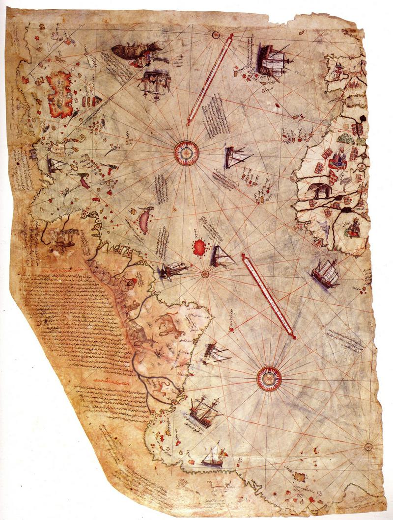
The Piri Reis world map, 1513. Artist: Piri Reis (1470-1553) (Photo by Fine Art Images/Heritage Images/Getty Images)
A medieval-era map, discovered in a Turkish palace in 1929, is dated 1513, yet it shows a knowledge of faraway lands well beyond the areas European explorers had traveled and even shows land features Europeans couldn’t possibly of known about in 1513…like the Andes Mountains of South America and the coastline of the Antarctic under the ice. The map, drawn on a piece of gazelle skin, was said to be the work of Piri Reis, a cartographer and admiral in the Turkish army. The amazing accuracy of the Piri Reis map has scholars scratching their heads. Is the map proof of an ancient, yet advanced, seafaring civilization?
Piri Reis Cited His Sources
When drawing up his map, Piri Reis consulted as many as twenty other maps, some dating back to the time of Alexander the Great. The cartographer was careful to note his sources on his map, which he dated 1513.
The Piri Reis Map Shows the Antarctic Land Mass
Antarctica is more than 98-percent covered in glacial ice and snow. The continent of Antarctica was discovered in 1818, several hundreds of years after the Piri Reis map was drawn, yet it shows a land mass where Antarctica is. This, in and of itself, is astonishing, but there are more curiosities. The coastline of this land mass was unfamiliar and therefore deemed inaccurate, for hundreds of years until 1961. It was then that Captain Lorenzo W. Burroughs, a captain in the U.S. Air Force cartography division, noted that the outline of this southern land mass seemed to accurately depict the coastline of the continent under the ice.
How is this possible, given the limitations of the surveying equipment in the 1500s? One theory is that the map was drawn using information on older maps that were made so long ago that it was before Antarctica was covered in ice. If that is the case, it is proof of an advanced, and much older civilization that pre-dates known civilizations.
The Piri Reis Map Shows Antarctica Attached to South America
One odd inaccuracy in the Piri Reis Map is that the tip of South America is attached to Antarctica. One theory to explain this connects to the idea of continental drift, the belief that all of the continents once formed a giant land mass that has split into small land masses and drifted to their present locations via plate tectonics. It is theoretically possible for Antarctica to have been attached to South America, just as the Piri Reis Map shows, in the distant past and that is broken off from South America and formed its own continent after pre-historic seafarers charted this part of the globe. Even if this shift was the last breakage of the original giant land mass, it still would have occurred much longer ago than known human exploration.
The Map Notes the Arctic Winter
Piri Reis added a note on the map he created that translates to say, “It is related by the Portuguese infidel that in this spot night and day are at their shortest of two hours and at their longest of 22 hours.” Due to the tilt of the Earth, the winter months in the polar regions receive very little, if any daylight. During the summertime, however, the sun never sets and the region experiences constant sunlight. Piri Reis indicates that he was given knowledge of this from the Portuguese, but no known Portuguese sailor had ventured that far south in the 1500s. Oddly, Piri Reis positioned this notation near South America, much further north than the regions affected by the polar winter. It could be that he simply added the notation where there was room. Other experts believe that South America was once further south of its present location and has since drifted north.
The Piri Reis Map is Amazingly Accurate
The coastlines of South America and Africa, as shown on the Piri Reis Map, as surprisingly accurate…within a half a degree of longitude. The Equator is also in the precise location. Prior to 1790 when the marine chronometer was invented, sailors, navigators, and cartographers had no accurate way to accurately pinpoint a given location, yet the Piri Reis map seems to have done that long before it was possible.
The Piri Reis Map Shows Interior Land Features
Even if navigators did sail down the coast of South America, Africa, and Antarctica, the Piri Reis Map should only indicate coastal features. Yet, the Andes Mountains of South America are accurately portrayed on the map. Rivers are even included. The inclusion of these land features means that Piri Reis had knowledge of more than just the coastlines of the continents on his map.
Does the Piri Reis Map Show Ancient or Advanced Knowledge?
Some experts claim that the Piri Reis Map is proof that there were advanced civilizations on Earth at a much earlier date than known civilizations. Others claim that the map shows that continental movement occurred more recently than geologists believe. Still, others claim the map is a work of fiction and that it was dumb luck that it has proven to be so accurate. Of course, there are others that are quick to point to alien technology. We may never know how the information on the Piri Reis Map was discovered and the ancient map remains a historical mystery.