Niagara Falls From Above: A Bird's Eye View
By | September 12, 2019
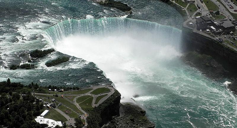
This aerial view shows the Horseshoe Falls section of Niagara Falls on June 14 2012 in Niagara falls, New York. Source: (pinterest.com)
If you have ever visited Niagara Falls, then you can attest to the splendor of the tremendous rush of water that pours over this spectacular series of waterfalls that straddle the U.S.-Canadian border. But a view from above shows you the sheer power of water to erode through solid rock. An aerial view of Niagara Falls lets you appreciate just how close it is to completely draining Lake Erie. What does Niagara Falls look like from above? Let's see how the Falls got to such an overpowering state and what the future looks like.
Horseshoe Falls...it is easy to see how it got its name. Source: (facebook.com)
A Bit About Niagara Falls
Niagara Falls is not just one but three waterfalls: Horseshoe Falls (the largest and most impressive of the three), American Falls, and Bridal Veil Falls. They all have separate names because they got mad about constantly getting lumped together.
The Great Lakes are not all at the same elevation, so when the water drains from four of the Lakes—Superior, Michigan, Huron, and Erie—it gets bottlenecked at the deepest point between Lake Erie and Lake Ontario. Here, in the narrow Niagara Gorge, all of the water converges and tumbles down the rocks on its way to Lake Ontario, the St. Lawrence River, and eventually the Atlantic Ocean.
More than 681,000 gallons of water cascade over Horseshoe Falls every second. Source: (foxnews.com)
That's a Lot of Water
There is a lot of water in the Great Lakes—about one-fifth of all the fresh water on the planet. Every second of the day, about 3,160 tons of water cascades over Niagara Falls. Horseshoe Falls also sees more than 681,000 gallons of water rushing over its side per second. When it falls, the water reaches a speed of up to 32 feet per second, hitting the base of the Falls with a force equal to 2,500-plus tons.
Moving water is a tremendously powerful force. Source: (csmonitor.com)
The Power of Water
If studies of the Grand Canyon in Arizona have taught us anything, it is that water is an incredibly powerful tool that can cut and carve through solid rock. Geologists believe that, more than 10,000 years ago, the falls were in a much different location. Scientists place their former location near the present-day towns of Lewiston, New York and Queenston, Ontario. As the water ate away at the cliff face, the waterfall retreated, inching its way closer to Lake Erie. Currently, it is 7 miles from this spot. Half a foot per year might seem like a slow pace to you, but you're not a disappearing rock.
Goat Island splits the Niagara River. Source: (niagarafallslive.com)
Water Works
The water also changed the shape of the falls. Geologists believe that Horseshoe Falls was once a small semi-circle, but it has expanded to its present width of 2,600 feet. When the Falls retreated to their current location, a rocky, granite island in the Niagara River called Goat Island diverted the flow of water into two streams, forming the three distinct waterfalls we currently see.
Lake Erie is the shallowest of the Great Lakes. Source: (toledoblade.com)
Bye, Bye, Lake Erie
Each year, Niagara Falls inches closer to Lake Erie, about 20 miles away. When the Falls get close enough, Lake Erie will drain directly into the fall. It'll surely be a spectacular sight, but as the falls reach the lake, it is likely that Lake Erie, the shallowest of all the Great Lakes, will decrease in size by as much as half. The shorelines, which mark the border between the United States and Canada, will be much closer together than they are now. In fact, some studies show that Lake Erie may transform into a river instead of a lake.
About 30 million people visit Niagara Falls annually. Source: (niagarafallsstatepark.com)
A Long Time Coming
Don't worry: If you have plans for a fishing trip on Lake Erie, you don't have to cancel your trip. It could take as long as 50,000 years for the Falls to eat away at the 20-mile stretch to Lake Erie. In the meantime, the Falls welcome as many as 30 million people each year seeking to marvel at the power of the moving water and/or recreate that episode of The Office.